The Wild Days guide
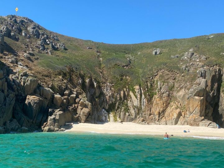
Portheras is a wild little cove of pale sand at the foot of a steep valley between Pendeen and Morvah. There is no road, no cafe and often no one else, just seals in the water and granite cliffs either side.
Why it’s worth the trip
You have to walk to Portheras, which is half the point. From Pendeen lighthouse the coast path dips past the fishermen’s slipways at Boat Cove and then down steps to the sand, where a stream runs out across the beach to the sea. The sand is crushed shell, like Sennen’s, and very pale against the dark rocks.
It is a beach for sitting, picnicking and watching wildlife rather than swimming, for reasons explained below.
Make a wild day of it
Seals and wildlife
Grey seals are often seen in the cove or hauled out on the rocks, and dolphins sometimes pass offshore. Keep your distance and keep dogs back so the seals are not disturbed. The path in crosses heathland with wide views along the coast.
Walk to Zennor
East of Portheras begins one of the toughest and finest stretches of the whole South West Coast Path: the sheer climbing cliffs of Bosigran, the Iron Age fort on Gurnard’s Head and the mermaid village of Zennor. It is rough going and slower than it looks on the map. Bus 16A from Zennor can take you on to St Ives or back to Penzance on weekdays and Saturdays.
History
In 1963 the coaster Alacrity ran aground in the cove and was blown up where she lay, leaving razor-sharp metal in the sand. Parts of the beach were closed for years until volunteers cleared the worst of it in 2004. Pendeen lighthouse, lit in 1900 after a long run of wrecks, stands on the headland to the west.
Tides and safety
There are no lifeguards. The South West Coast Path Association advises against swimming here because sharp fragments of the Alacrity may still lie under the sand. Currents can be strong, and at high tide there is often a heavy shore break.
Come down on a falling tide for the most sand and keep an eye on the water so you are not cut off on the rocks at either end. The path and steps down are steep and uneven. In an emergency call 999 and ask for the Coastguard.
When to go
Late spring and early autumn, on a calm day with a falling tide, are perfect. Summer weekends bring a few more people, but it never feels crowded. Winter is for watching storms from the cliffs.
Good to know
- Parking: roadside spaces at Pendeen Watch, about 1 km away along the coast path, or a farm field car park above Rose Valley (small fee) with a steep 15 minute walk down.
- Facilities: none. Take water and food. The North Inn and shops are in Pendeen.
- Dogs: allowed all year; keep them on a lead on the cliffs and near livestock.
- Bus: Go Cornwall Bus routes 4 and 4A stop in Pendeen and Morvah.